Trail Walking Le Reposoir - Col des Annes du Reposoir - Photo
 GrouGary
GrouGary

User

© OpenStreetMap contributors
Length
Length
13.9 km
Max alt
Max alt
1726 m
Uphill gradient
Uphill gradient
775 m
Km-Effort
Km-Effort  
24 km
Min alt
Min alt
1035 m
Downhill gradient
Downhill gradient
780 m
Boucle
Boucle
Yes
Creation date :
2024-05-24 07:22:47.834
Updated on :
2024-05-28 12:39:37.163

(0 Reviews)

Walking
Walking
5h30
Difficulty : Difficult

Scan this QR Code to open this trail in the SityTrail application

FREE GPS app for hiking

Logo SityTrail SityTrail

IGN / Geographical institutes

Download SityTrail from the App Store Download SityTrail from Google Play

Logo SityTrail SityTrail World

The world is yours!

Download SityTrail from the App Store Download SityTrail from Google Play Download SityTrail on Huawei AppGallery

About

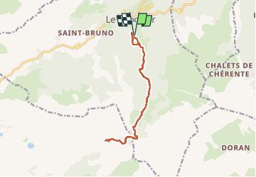
Trail Walking of 13.9 km to be discovered at Auvergne-Rhône-Alpes, Upper Savoy, Le Reposoir. This trail is proposed by GrouGary.

Description

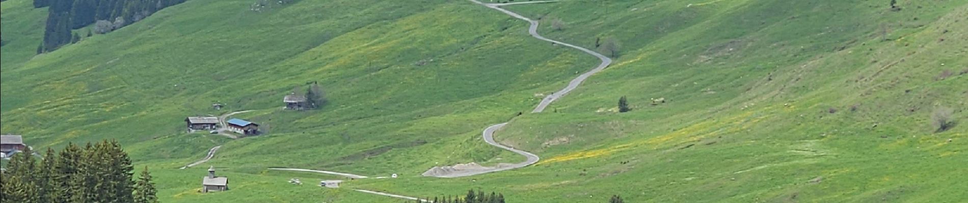
A/R  au Col des Annes à partir de la Grande Chartreuse du Reposoir : Montées soutenues mais sans difficultés.
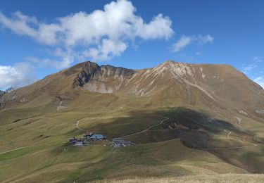
Belle surprise : L'arrivée des vaches en transhumance au Col des Annes.
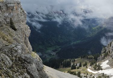
R : Trop de neige pour atteindre le Col de l'Ouletta   pluie menaçante.

Elevation profile

Photos

Positioning

Country:
France
Region :
Auvergne-Rhône-Alpes
Department/Province :
Upper Savoy
Municipality :
Le Reposoir
Location:
Unknown
Start:(UTM)
309279 ; 5097637 (32T) N.

Trails nearby

Trail Walking Le Reposoir - Le Petit Bargy 2098 m, depuis Malatrait - Photo
Walking
tracegps

Walking

Medium
(1)
Le Reposoir, Auvergne-Rhône-Alpes, Upper Savoy, France
8.1 km | 18.8 km-effort
5h 0min
Yes
Trail Walking Le Reposoir - au dessus de la grotte de motarquis - Photo
Walking
GUIDE
nadd73

Walking

Difficult
Le Reposoir, Auvergne-Rhône-Alpes, Upper Savoy, France
10.1 km | 24 km-effort
6h 0min
Yes
Trail Walking Le Reposoir - pointe blanche par l'arête Est - Photo
Walking
GUIDE
nadd73

Walking

Difficult
Le Reposoir, Auvergne-Rhône-Alpes, Upper Savoy, France
5.6 km | 17 km-effort
6h 0min
Yes
Trail On foot Le Grand-Bornand - Move - Photo
On foot
Sebastienburette

On foot

Easy
(1)
Le Grand-Bornand, Auvergne-Rhône-Alpes, Upper Savoy, France
6.5 km | 11.5 km-effort
Unknown
Yes
Trail Walking Le Reposoir - lac peyre - Photo
Walking
Jeroen82

Walking

Medium
(2)
Le Reposoir, Auvergne-Rhône-Alpes, Upper Savoy, France
5.1 km | 10.9 km-effort
2h 26min
Yes
Trail Walking Le Reposoir - Col de la Colombière - Pointe du Midi - Photo
Walking
sofracoan

Walking

Medium
(1)
Le Reposoir, Auvergne-Rhône-Alpes, Upper Savoy, France
11 km | 24 km-effort
3h 59min
Yes
Trail Walking Le Reposoir - Montée au Petit Bargy - Photo
Walking
Chabard

Walking

Difficult
Le Reposoir, Auvergne-Rhône-Alpes, Upper Savoy, France
10.4 km | 23 km-effort
4h 1min
Yes
Trail Walking Le Reposoir - Col de l'Encrenaz, pour le Petit Bargy - Photo
Walking
GrouGary

Walking

Difficult
Le Reposoir, Auvergne-Rhône-Alpes, Upper Savoy, France
7.3 km | 16.8 km-effort
3h 52min
Yes
Trail Walking Mont-Saxonnex - lac benit  - Photo
Walking
colomb24

Walking

Easy
Mont-Saxonnex, Auvergne-Rhône-Alpes, Upper Savoy, France
10.8 km | 18.9 km-effort
4h 43min
Yes


Close
My subscriptions